The Team
-
Andrew Powell grew up in Bridge of Allan and started as an archaeological volunteer in 1970. He graduated with an Honours degree in Archaeology from University College Cardiff, and spent his career working in commercial archaeology. He now lives in Killin and was involved in Scotland’s Rock Art Project where he first became involved in photogrammetry.
-
Elaine Black lives in Balquhidder and is a member of an archaeological field survey society. She graduated with Honours degrees in Scottish History & Literature, and Celtic Civilisation & Archaeology, at the University of Glasgow, and has a background in journalism and museums. She now works as a Scottish Blue Badge Tour Guide.
-
Charlie Hunter lives in Balquhidder. He is a Scottish Blue Badge Tour Guide with a career spanning more than 30 years and often assists visitors with genealogical research at Stirling Archive and elsewhere. He is Treasurer and Elder at Balquhidder Parish Church.
Photogrammetry
Digital photo record
Two sets of digital photos were taken for each graveslab (using a Panasonic DMC-TZ80 compact camera).
The first set comprises shots of each graveslab before work started, after cleaning, and following restoration of the turf, and shots (from N, S, E and W) showing a slab’s setting within the cemetery, and its relationship to nearby slabs and gravestones.
The second set comprises the data capture for the photogrammetry, and involves taking multiple, overlapping photographs of each slab. The number of photographs required varies depending on the size and complexity of the slab’s shape, but for most slabs 50–80 shots were taken.
3D Modelling
The creation of a 3D model by photogrammetry is achieved using Agisoft Metashape software. This recognises and matches shared points in adjacent photos, allowing the frames to be aligned. From the resulting ‘point cloud’ a wire-frame mesh is constructed reflecting the 3D shape of the slab, to which colour and texture is added back from the original frames.
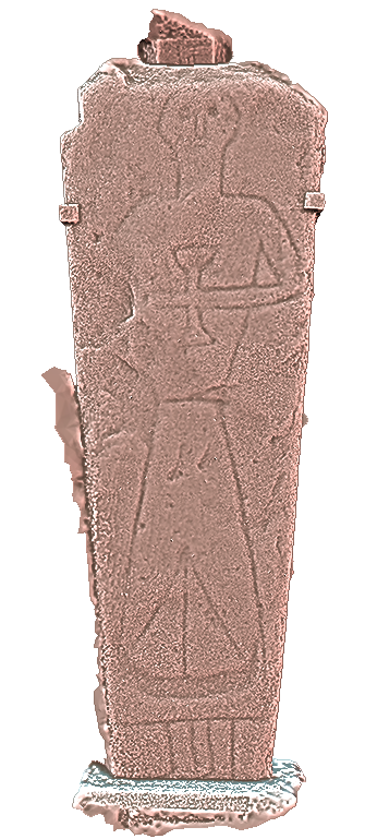
The resulting 3D object can be enhanced by importing it to MeshLab, free software that allows the model to be easily zoomed in on, rotated and lit from any angle. In addition, it can be rendered using a number of different shaders (eg, Radiance Scaling) that enhance the surface of the model and improve the visualisation of carved details and inscriptions which otherwise might not be seen.
As you can see on the Meshlab snapshot of the Angus Stone, now located in Balquhidder Parish Church, the detail which emerges allows us to see an iconic piece of Balquhidder history like never before. And is that a galley (ship) at the bottom of the cleric’s robe? It is certainly worth further investigation.
For graveslabs bearing carvings or inscriptions (or other markings of potential significance) the models are also uploaded to the online platform Sketchfab, where they can be publicly shared. Each model can be rotated, and its lighting and surface texture manipulated to enhance the visibility of any carvings. Visit Balquhidder Graveyard Claymore Project’s Sketchfab here.
Click on the button below to see photogrammetry in action and spin the Angus Stone around for a different perspective.
Site Plan
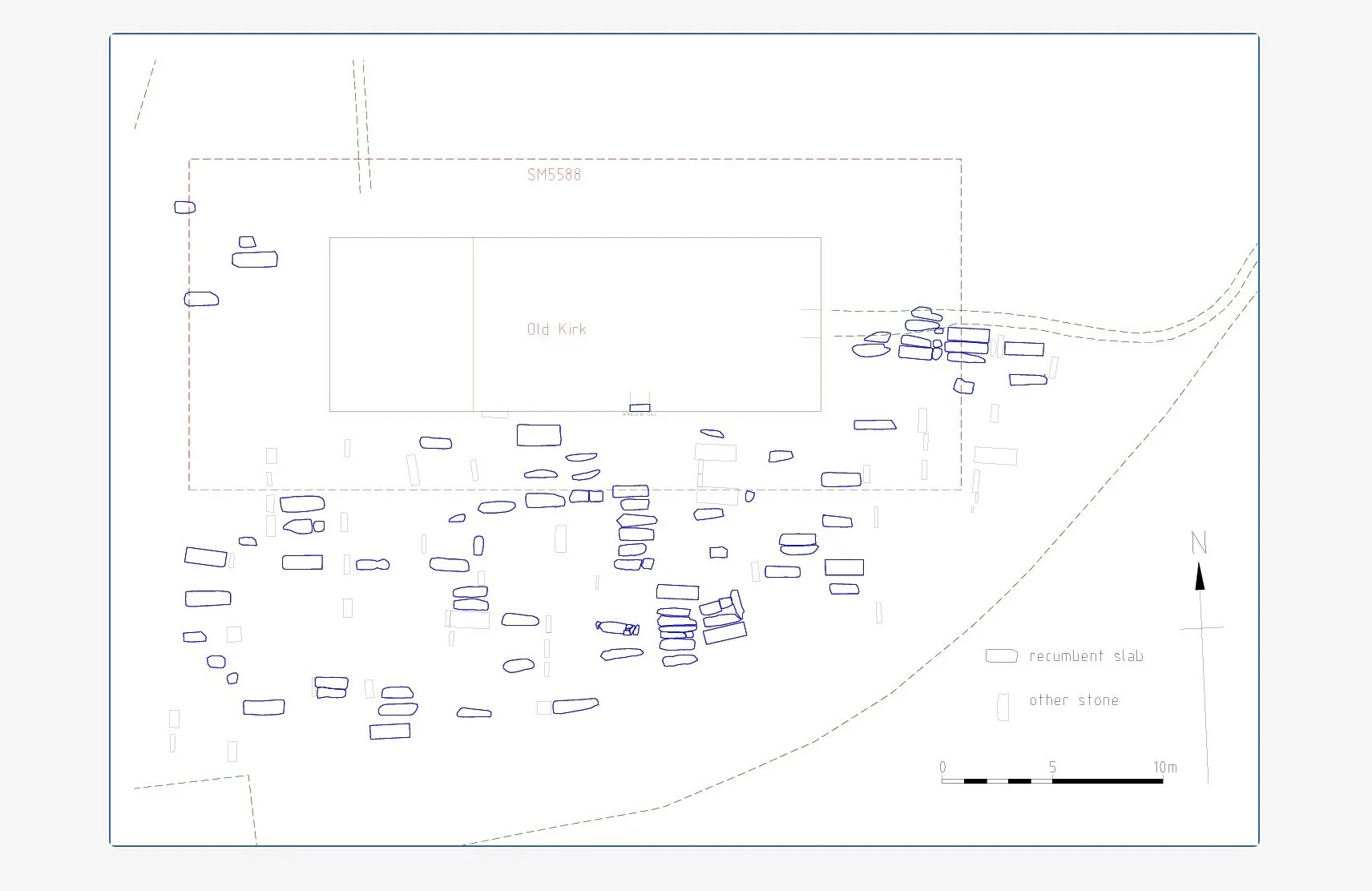
A key first step for the new project was to conduct a tape survey of the graveyard in order to create an accurate scale plan showing the locations of pre-1800s recumbent graveslabs (each of which is assigned a number when recorded), as well as their relationship to more recent headstones and memorials. To begin this process BGCP was able to use a partial sketch plan, drawn by Ian Fisher for the Royal Commission on the Ancient and Historical Monuments of Scotland in the 1990s.
The new plan also shows the locations of graveslabs in relation to the remains of the Old Kirk, and to the area around it which is legally protected as a scheduled monument (SM). The plan has a site grid aligned to the south wall of the Old Kirk, the coordinates of the Old Kirk’s SW corner being 20.00 m east/24.00 m north. As work progresses, and new graveslabs are identified and recorded, the plan will be continually updated. Once completed, it will help future researchers to access our information and find individual graves.
Record
The aim of the Balquhidder Graveyard Claymore Project is to produce an accessible and comprehensive record of the recumbent graveslabs in the parish churchyard, which will be of interest to the local community and to visitors, and of value to research.
The record comprises a number of parts which together will form the project archive, including a photographic record of each slab, before and during cleaning and after reinstatement, showing the slab’s setting within the graveyard, and its relationship to adjacent stones; all sets of photos include a 0.5 m scale and a North arrow.
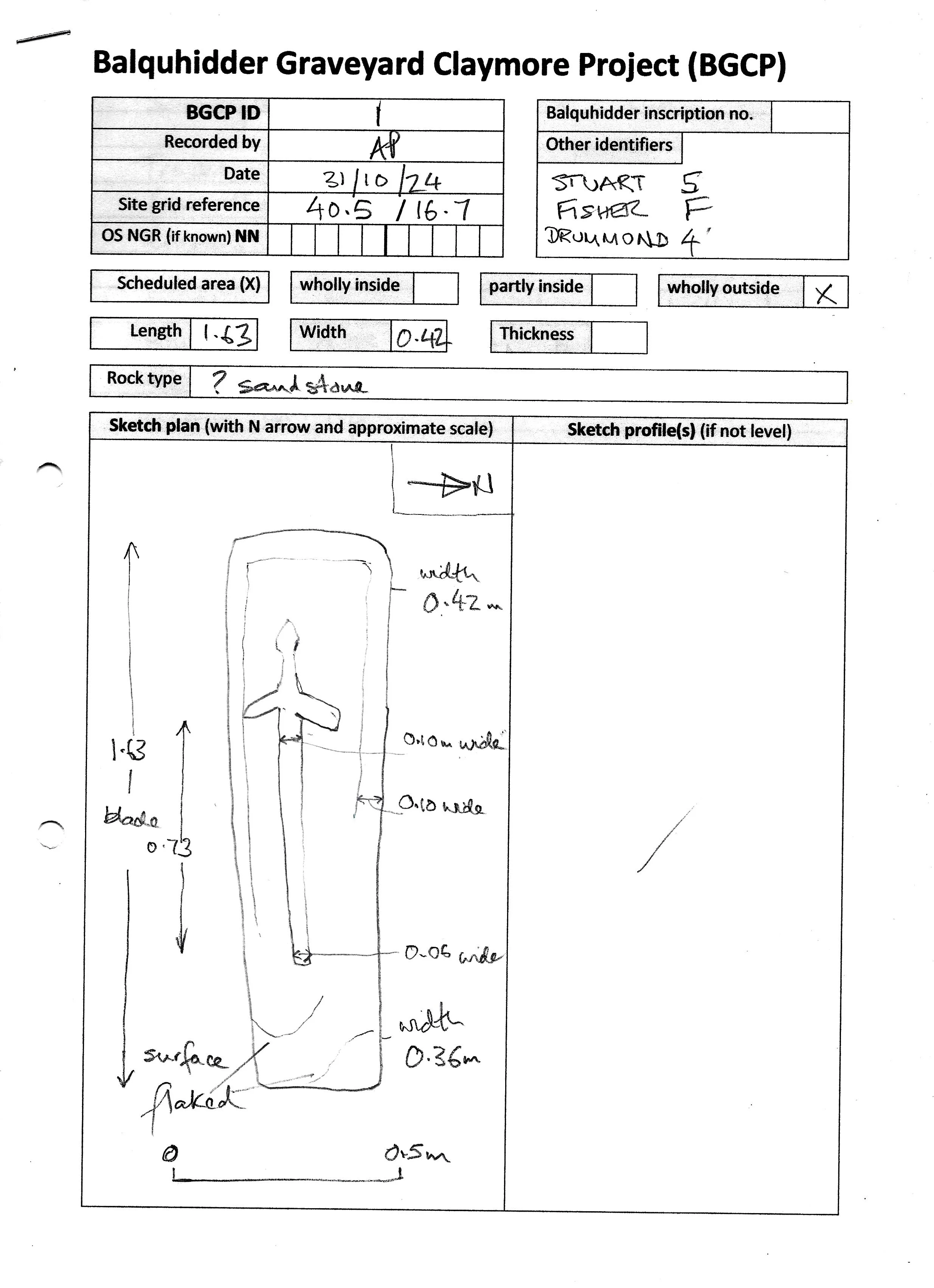
A paper record (using a standard form) is also made during the fieldwork, including an annotated sketch plan (and profile if appropriate), recording site co-ordinates, measurements, the locations of carvings and inscriptions, and other observations. The data is subsequently converted into digital form, but the paper record will remain part of the site archive.
Care is taken when exposing and cleaning the grave-slabs. Where possible, the turf is rolled back, or cut and lifted, taking care not to cause any damage to the stones. Any moss, loose lichen and soil is gently cleaned off using wooden or plastic spatulae (craft ‘lollipop’ sticks are best) and a soft brush, and surrounding weeds and grass is trimmed back with shears.
Once exposed, the slab is photographed for the 3D photogrammetry, and the resulting digital images, including the 3D models, therefore make up the large part of the project archive. Preliminary archive reports are being produced for each graveslab; these can be found here. They will be added to and amended as the project progresses and new information (eg, geological identifications) become available.
Permissions
The Balquhidder Graveyard Claymore Project is supported by the Minister and Kirk Session of Balquhidder Parish Church. BGCP is also grateful for the advice of Murray Cook, Stirling Archaeologist.
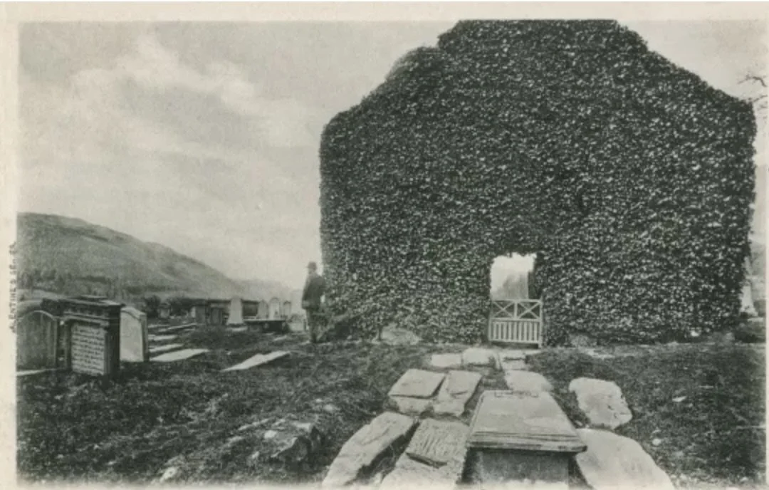
The graveyard of Balquhidder Parish Church contains a scheduled monument – SM5588 – because of the potential for medieval remains to survive below the 17th-century Old Kirk. This designation gives statutory protection to the Old Kirk and the area (35 m E–W by 15 m N–S) immediately around it. As a result, our project has been undertaken in two overlapping phases.
Phase 1. When the project formally started early in 2025, it was limited to that part of the graveyard outside the scheduled area. Permission to expose, clean and record graveslabs in the rest of the graveyard area was obtained from Stirling Council Cemeteries, which maintains the graveyard, and the Clan MacLaren Trust which maintains the fabric of the Old Kirk.
Phase 2. In June 2025 the project applied to Historic Environment Scotland (HES) | Àrainneachd Eachdraidheil Alba for Scheduled Monument Consent (SMC) so that we could extend the work up to (but not inside) the Old Kirk. Consent was granted at the start of August 2025, and the work has now extended into the scheduled area.